Many cruisers consider the Indian Ocean
to be a 'milk run', gentle trade winds all the way across. We found it to
be more challenging with light winds at times and on the nose at others - but
never dangerous. The new cultures were interesting and at the end we were
in the volatile Middle East.
|
Indian Ocean
This has been an introduction into new cultures:
Indian, Arab, and truly Muslim. And as usual, we have found the
people to be friendly and inquisitive as long as we respect their
customs and culture. In the 3000 miles across this ocean we motored a
lot and are glad to have 2 of the big 3 oceans behind us.
Pick a spot on the map to the left, or read on
... |
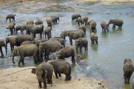
Sri Lanka
A 9-day sail from Thailand, this fascinating land, 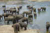 that used
to known as Ceylon, was beautiful!. Most cruisers stop here on their way
to the Red Sea, although the more adventurous would press on the Cochin, India or
the Maldives instead. The country is a little seedy due to a low standard of
living, but the water at the port was potable, the food was good, and the people are
nice. The highlights are tea plantations, temples, and elephants. Officials take advantage of their position by trying to squeeze
'gifts' out of us, but they accepted it when confronted with a polite 'No'. We
toured the countryside, so check out our experiences in
Sri Lanka. that used
to known as Ceylon, was beautiful!. Most cruisers stop here on their way
to the Red Sea, although the more adventurous would press on the Cochin, India or
the Maldives instead. The country is a little seedy due to a low standard of
living, but the water at the port was potable, the food was good, and the people are
nice. The highlights are tea plantations, temples, and elephants. Officials take advantage of their position by trying to squeeze
'gifts' out of us, but they accepted it when confronted with a polite 'No'. We
toured the countryside, so check out our experiences in
Sri Lanka.
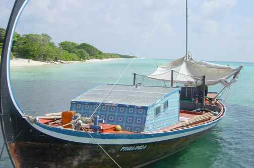
Maldives This
string of islands 500 miles long lies across the route to the Red Sea. They are
beautiful, reminiscent of the South Pacific islands with white sandy beaches,
swaying palms, and warm breezes. The capital, Mal�, in the middle of the
string is out of the way for yachts in transit, so cruisers are now stopping at Uligan, the northern-most atoll. We stayed there for a week, stocking up
on a few items and absorbing a little about this Muslim culture in the middle of
an ocean. Check out our Maldives page for more
details. 500 miles long lies across the route to the Red Sea. They are
beautiful, reminiscent of the South Pacific islands with white sandy beaches,
swaying palms, and warm breezes. The capital, Mal�, in the middle of the
string is out of the way for yachts in transit, so cruisers are now stopping at Uligan, the northern-most atoll. We stayed there for a week, stocking up
on a few items and absorbing a little about this Muslim culture in the middle of
an ocean. Check out our Maldives page for more
details.
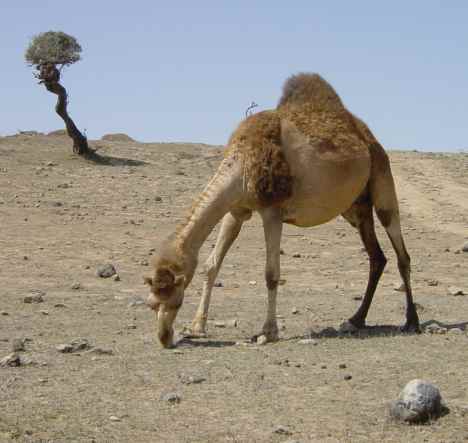
Oman
This was our first Arab country -  and we were
delighted! Oman has oil, and the enlightened Sultan appears to have used
much of the wealth wisely as the infrastructure is good - wide, smooth roads,
clean water, well-dressed and proud people, and well-educated youths from what
we could tell. The abundance of camels reminds you that the desert is near
and that many still live rural lives. The people were really friendly to
us - although relations cooled a little when the US started bombing Iraq. The Oman
page has more information. and we were
delighted! Oman has oil, and the enlightened Sultan appears to have used
much of the wealth wisely as the infrastructure is good - wide, smooth roads,
clean water, well-dressed and proud people, and well-educated youths from what
we could tell. The abundance of camels reminds you that the desert is near
and that many still live rural lives. The people were really friendly to
us - although relations cooled a little when the US started bombing Iraq. The Oman
page has more information. Gulf
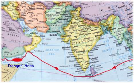
of Aden Sea stories about piracy at sea
always seemed distant - until now! In the week before we had to transit
the Gulf of Aden two yachts on our radio net were attacked, one boarded and
robbed and the other one merely shot at. We started calling the area
between Yemen and Somalia the Danger Area.
We took copious precautions by hiding items of value, setting up contingency
plans, traveling in company with another yacht and at night. Either luck
or precautions worked and we made it through unscathed and much relieved. Our
Journal page for March 2003 has
all the details, plus a real-life account of a pirate attack.
Yemen We
had heard many  negative stories about this war-torn country, and the fact that a
US warship had been bombed here a year earlier put us off a little, but we are
glad we stopped. The people (as usual) were wonderfully friendly. We
engaged a driver/guide/advisor for 3 days and Salim made our stay
memorable. He showed us the highlights of Aden, took us to restaurants and
helped in many ways. Our Yemen page tries to
capture the highlights of this fascinating country. negative stories about this war-torn country, and the fact that a
US warship had been bombed here a year earlier put us off a little, but we are
glad we stopped. The people (as usual) were wonderfully friendly. We
engaged a driver/guide/advisor for 3 days and Salim made our stay
memorable. He showed us the highlights of Aden, took us to restaurants and
helped in many ways. Our Yemen page tries to
capture the highlights of this fascinating country. |